Pacton Gold has started field activities on its large gold property portfolio in the Pilbara craton.

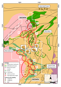
Image: Map of E47/3476 and E47/3478 prospects. Photo: courtesy of Pacton Gold Inc.
Initial exploration will take place on Pacton’s Arrow Project, 90 km SSW of Port Hedland, Western Australia. The tenement is located on the shallow northern margin of the Pilbara conglomerate gold province, where Arrow Minerals discovered gold nuggets 5 to 10 mm in size, recovered from outcropping conglomerate. Pacton Gold currently owns 51% of the Arrow minerals property and is accelerating its ownership to 100%.
In 2017, Arrow completed a short prospecting programme on E47/3476 and a targeting exercise over E47/3476 and E47/3478, which identified nine conglomerate and basement gold targets.
The Company’s current Arrow North exploration programme, consisting of geologist and prospector teams, will consist of metal detection and gold nugget sampling of three identified pit locations and additional pits along their bedding extensions. Additionally, future pit and drill locations will be identified using geological mapping and radiometric methods. Geological mapping will also include particular attention to faults and other structural splays related to the larger Mallina shear zone that hosts gold deposits located immediately north of the Arrow North tenement.
The immediate field geological programme and a coincident local geophysical review on the combined Arrow project is also designed to provide a framework for the planning and execution of forthcoming exploration programs over Pacton’s large Pilbara property portfolio.
Prior to announcing its first of six Pilbara project acquisitions in February, 2018, eventually making Pacton the 3rd largest landholder in the Pilbara gold play, the Company began the compilation of a comprehensive geological database of the Pilbara craton. This database includes government land tenure and cadastral datasets; geological, geochemical and geochronological data; and imagery from several satellite platforms. Pacton has already surveyed all of its tenements using multispectral satellite derived datasets, at a resolution of 10 m per pixel and has successfully mapped distinct conglomerate lithologies (sedimentary layers) and orogenic shear zone targets. The Company is currently finalizing specifications for an airborne multispectral Lidar survey to collect high resolution elevation, structural, lithological and mineralogical information from all its project areas, beginning with the Arrow projects.
The Company further advises that it has appointed Jonathan King to the role of Chief Geologist and General Manager of Exploration, responsible for the management and implementation of the Company’s exploration and exploitation programmes. Mr King has extensive experience in minerals exploration and management services. For over 25 years, Mr King has worked for a number a public and private companies, specialising in exploration, logistics and discovery excellence. Most recently, Mr King has been a technical and corporate consultant, providing clients with strategic advice in regolith geology/geochemistry (including mapping and targeting), exploration strategy, drilling program design, project divestments and acquisitions, project due diligence and resource evaluation, preparation of independent geological reports and tenement and general compliance management.
“Following an aggressive and successful property acquisition program to become a major player in the Pilbara play, the most exciting gold play in the past 40 years, we have commenced our exploration campaign, starting with our Arrow tenements. Our greater Pilbara focus is on gold, primarily in conglomerates, while keeping a watch for high grade orogenic shear systems. In keeping with our management philosophy, we intend to explore aggressively and rapidly with Jonathan King, our new Chief Geologist, leading the charge,” commented Alec Pismiris, Interim President and CEO of Pacton.
