Sedimentation is reducing the capacity of Tajikistan’s Nurek reservoir, threatening the long term viability of a nationally important hydropower operation. HR Wallingford is leading a project to analyse, map and model the scale of the sedimentation, in order to help the national power company, OSHC Barqi Tojik, develop their long term management strategy for the reservoir. The work will help to maximise the life of the power station and secure its effective operation for the long term. Jonathon Taylor, Principal Scientist at HR Wallingford, gives more details.
Rising in the Parmir Mountains of Tajikistan, the Vakhsh River drains an area roughly the size of Switzerland, and discharges some 20km3 of water each year. Unfortunately it is not only water that the river Vakshk carries downstream, but also tonnes of sediment. This sediment causes problems for hydroelectric power infrastructure sited on the river by reducing the reservoir storage capacities and damaging turbine systems.
The 300m tall Nurek dam on the Vakhsh is the second tallest dam in the world. Built during the 1960s when Tajikistan was part of the former Soviet Union, the dam impounds a 70km long reservoir with a capacity some fifty times greater than the largest reservoir found in the UK. The dam’s nine turbines contribute some 3015MW of power, representing the single largest point of generating capacity in the country.
Since its construction sedimentation has significantly reduced the reservoir’s storage capacity. Between impoundment in 1972 and 2001, the reduction in storage capacity is estimated to be 2km3, some 20% of the reservoir’s original volume.
Without effective management, the sediment build up has the potential to significantly impact on the power generating capacity of the Nurek facility with the result that the country’s power demands would no longer be satisfied.
With funding from the World Bank, a team of surveyors and scientists from HR Wallingford has taken up the challenge of not only quantifying the magnitude of the sediment problem, but also building the tools for its future management.
Managing sedimentation
Strategies for managing sedimentation include bypassing of the sediment by dropping the stored water level during the period of highest sediment input, flushing of the sediment and the active removal of accumulated sediment by dredging. In order to identify which strategy is most appropriate, a detailed knowledge of the sediment yield from the catchment, the sediments being deposited, as well as the variation of water levels in the reservoir through both seasonal variation in the inputs and its operational use is required.
The Rogun dam presently being constructed immediately upstream of Nurek, whilst undoubtedly reducing the quantities of sediment entering the Nurek reservoir, will require modification to the existing operational strategy of the Nurek reservoir. A combined operational approach that will control sedimentation in both the Rogun and Nurek reservoirs is the desired outcome.
The Nurek sedimentation project was established to collect information on the sedimentation regime of the reservoir and to develop a modelling tool that can be used to evaluate the different management strategies available to achieve this goal.
Determining bathymetric change
Limited historical bathymetric survey information exists for the Nurek reservoir, comprising a series of 25 cross-sections spanning the reservoir which have been repeatedly surveyed at intervals over its lifetime. Analysis of this data shows the progressive accumulation of sediment since impoundment (Figure 1).
As can be seen, advance of the wedge of deposited sediment is now at a point where a detailed bathymetric survey is required. The project’s survey team have therefore executed a high resolution survey of the reservoir using state of the art GPS positioning and dual frequency echo-sounding techniques, from which storage volume estimates can be derived.
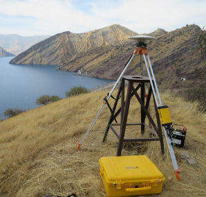
The team installed GPS receivers at established benchmarks located high above the reservoir. High resolution positional information was derived from these instruments, through processing of the carrier waves transmitted by the satellites to produce positions with an accuracy of <10mm in the horizontal and <20mm in the vertical.
The bathymetric survey performed in autumn 2015, when the reservoir levels were at their highest, captured bathymetric data along 680km of planned survey lines spanning the reservoir. Using this information a digital elevation model of the reservoir has been built from which the reservoir’s storage volume can be estimated. The team is now undertaking the final stage in the process to compare these values against the historical bathymetric data sets available to establish the change that has occurred.
Training and equipment has been provided to local personnel to allow them to continue the programme of periodic high resolution surveys for the future monitoring sediment infill rates and assessment of the effectiveness of the sedimentation management strategies.
Reservoir sediment deposits
The sediments accumulating in the reservoir range from fine clays close to dam, to cobbles and boulders in the canyons of the Vashkh river. It is the fine sand fraction (100-200m), however, which dominates the sediments deposited within the reservoir, forming delta deposits which have extended to within 24km of the dam.
As part of the study, 19 sediment cores were collected along the length of the reservoir. Gravity coring techniques were used to access the submerged sediment deposits and rotary drilling techniques were used where the spring low reservoir levels allowed access to the sandy areas of the upper delta. Figure 4 shows these techniques being put into practice in the deeper section of the reservoir and on the sediment deposits located some 24km upstream of the dam.
Each core was labelled and transported to the project’s on-site sedimentology laboratory where it was described and analysed to determine the variations in particle size and bulk density over its full length.
As well as providing critical data for volumetric calculations of the sediment infill, the core samples provide information on the consolidation processes occurring within the sediment deposits on floor the reservoir, and will ultimately allow an understanding of how the sediments compact over time.
Measuring the inputs
Sediment inputs have been monitored since the dam’s impoundment at a gauging site near the village of Kishrog, some 70km above the dam.
The gauging station lies at the bottom of a gorge and comprises a 140m long cableway spanning the river channel. A funicular carriage runs along the cableway allowing the operator to pull the carriage out over the river such that measurements can be made by lowering instruments from the carriage into the flow using the carriages integrated winch system.
At the time of the project team’s initial visit to the site in spring 2015, the river was discharging between 770 and 835m3/sec, with surface velocities of the order of 5m/sec. The peak flow period, however, typically records discharges in excess of 1000m3/sec with flow velocities of 8m/sec. Despite the relatively "mild" conditions at the time of the project team’s visit the flows were still supercritical with standing waves present across the section.
Bringing it all together
HR Wallingford is using the data collected over the two field campaigns to build a detailed numerical model of the reservoir system in RESASS, their specialist sedimentation modelling software. RESSASS is a long-term one dimensional model capable of modelling sand/silt/clay mixtures including non-equilibrium deposition and erosion, compaction of sediment taking into account various reservoir operation strategies.
RESASS can simulate long term deposition patterns in a reservoir and predict the effect of various different intervention techniques on reservoir storage capacity. The model will enable the dam’s operations team to assess the impact on sediment flow of different environmental conditions and operating scenarios, and will provide an understanding of the rate at which total and live storage capacity will be lost in the future. Simulated scenarios will investigate the base case (business as usual) and the impacts of sediment trapping upstream due to the construction of the Rogun dam, as well as the release of sediment laden density currents to flush sediment from the Rogun reservoir.
Calibration of the model and validation on an independent data set will be performed. The datasets available are longitudinal profiles for years 1989, 1994 and 2001, and longitudinal profile and composition of the deposits for the present survey. HR Wallingford will use previous experience on calibration processes gained on other big reservoirs such as Tarbela in the Indus River in Pakistan.
Once the model has been calibrated, different sediment management strategies will be simulated and an assessment made of the various management options available, so that a long term management strategy can be developed which allows maximisation of power production without compromising the life of the reservoir.
Jonathan Taylor, Principal Scientist, HR Wallingford. Email: j.taylor@hrwallingford.com
www.hrwallingford.com