The quest to increase the holding capacity of Oregon’s Henry Hagg Lake to meet the region’s future potable water needs was a daunting enough task. But recent concerns about the possible seismic effects on Scoggins Dam have brought additional challenges to this project, writes Arlan Rippe
If Oregon’s Tualatin Basin is to have enough water to support the region’s growing water demands over the next 50 years, it must significantly increase its existing supply of clean water. A large portion of potable water in the Tualatin Basin is derived from Henry Hagg Lake, which is created by Scoggins Dam.
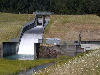
Built in the mid-1970s by the US Bureau of Reclamation (USBR), Scoggins Dam and Henry Hagg Lake reservoir were constructed to provide stored water for irrigation, flood control, municipal and industrial needs, recreation, fish and wildlife preservation, and water quality protection. The dam supplies drinking water for nearly 400,000 residents, provides irrigation water for more than 17,000 acres (6878ha) of prime agricultural land, and ensures adequate summertime flows in the Tualatin River to protect fish and wildlife and improve water quality. When the reservoir is full, it covers 1132 acres (458ha) and stores approximately 59,950 acre-feet (74Mm3) of water.
In 2001, local water agencies and municipalities in Washington County, Oregon, initiated the Tualatin Basin Water Supply Project. This basin-wide, integrated water resource management project sought to diversify the region’s water supply and meet the 50-year needs for water quality and critical habitat improvements in the Tualatin River and its tributaries; cities, industry and economic development; and agriculture.
Of the available options, the Water Supply Partnership focused on the option to approximately double the capacity of Henry Hagg Lake. Yet, it’s what goes on far beneath the surface that could derail this highly visible and necessary project. The Scoggins Dam sits atop the Cascadia Subduction Zone (CSZ), a major fault line that runs off the Oregon Coast that scientists believe could produce a magnitude 9.0 earthquake.
As part of the Tualatin Basin Water Supply Project, local water agencies in Washington County initiated a Dam Raise Appraisal Study (DRAS) in 2008 to determine the feasibility of doubling the reservoir while protecting this valuable resource from a potentially catastrophic seismic event.
Doubling supply
The Scoggins Dam/Henry Hagg Lake project involves adding another 52,000+ acre-feet (64Mm3) and raising the half-mile-long dam by about 40 feet (12.2m). The raised dam is to be the centerpiece of the Tualatin Basin Water Supply Project proposed by a consortium of regional water purveyors. A portion of the additional water would be from off-stream storage pumped from the Tualatin River during the winter months. In addition to regional drinking water supply, it would also supplement summertime flow for the Tualatin River to enhance water quality and temperature.
The Tualatin Basin Water Supply Project partners contracted with Kleinfelder as the lead consultant to prepare the DRAS in 2008. The study would evaluate alternative designs to raise the height of Scoggins Dam by 40 feet (12.2m) and increase the holding capacity of Henry Hagg Lake to meet the region’s future potable water needs and evaluate the area’s seismic conditions.
Kleinfelder’s challenge was to develop conceptual-level designs to 15% of completion and provide cost opinions for three scenarios:
• Earthquake mitigation of the existing dam.
• Raising the existing dam 40 feet (12.2m).
• A new dam downstream.
The project team includes several subconsultants, including: AMEC Geomatrix, BasePoint Design, Advanced Weather Associates, West Consultants and GeoSystems.
The draft conceptual design report included a detailed cost analysis of each alternative scenario and was delivered to the project partner/sponsors in July 2009. A project of this complexity within this shortened timeline required three independent teams, one for each scenario, working simultaneously on analysis and design.
To meet the challenge, Kleinfelder gathered resources from five offices and three laboratories, as well as key project members from the subconsultants and project experts scattered around the US. These included experts in seismology, earthquake engineering, geotechnical engineering, engineering geology, hydraulics and hydrology, dam design and construction, structural engineering, construction scheduling, and cost estimating. The DRAS team coordinated their efforts with the environmental consultants preparing the environmental impact studies for the water supply project.
This is likely the first time that a major structure such as this will be designed for a nearby magnitude 9.0 seismic event. Therefore, every scenario required evaluation and analysis of the effect on an existing dam due to a great subduction zone earthquake on a high-hazard dam (i.e., significant population downstream). Further complicating the seismic picture, a shallow crustal fault was geologically mapped running up the right side of the Scoggins Valley beneath the existing and proposed downstream dam site. Peak ground accelerations of the local shallow earthquake would be expected to be higher than the subduction zone earthquake, but the duration of strong motions from the subduction zone would last much longer and be more damaging. Consequently, the CSZ event will control final design.
Seismic sampling
USBR had begun its own dam safety and risk analyses of the existing dam at the same time as the Dam Raise Appraisal Study was started. During the summer of 2008, its scientists and geotechnical experts had drilled a series of holes on the Scoggins Dam slope to extract samples down to bedrock to update data from original design investigations. The investigation also included cross-hole seismic velocity profiling.
The Kleinfelder team assimilated the current and historical data obtained from the USBR and completed supplemental field investigations including borings, geophysical profiling and laboratory testing. Design analyses required preparation of numerical computer models to simulate the effects of a magnitude 9.0 quake lasting for two minutes along the subduction zone.
Each scenario is numerically modelled using FLAC (Fast Lagrangian Analysis of Continua), developed by Itasca, to evaluate seismic deformation potential. This effort required developing appropriate ground motion models based upon representation of a major subduction zone event.
Further, the study includes cost estimates for meeting current seismic standards for the design and construction of the three dam options that were analyzed in the DRAS. A fourth option was developed during the course of the study that considered an alternative construction method. The Tualatin Basin Water Supply Project partners have also updated cost estimates for the expanded pipelines, pumping facilities and water treatment capacity necessary to deliver the needed water.
In addition to the comparative designs and opinions of probable costs, the project partners have participated in several workshops to evaluate rating and weighting criteria that also considers impacts on environmental issues. These will be used as a basis for comparing the options and helping the team decide on the best course of action for this portion of the project.
Some of the environmental issues considered include terrestrial and aquatic life (including migratory salmonids), water quality and quantity, floodplains and wetlands, archaeological and historical resources, and socioeconomic and cultural impacts. The availability of construction materials, disposal of foundation excavation spoils, and impact on historic and ancient landslides also affect the comparison of alternatives.
The DRAS is currently being used to guide regional policymakers as they decide how and where Tualatin Basin communities will secure their future water supply.
The price of expansion
Because of the seismic design criteria, the anticipated cost of the entire Tualatin Basin Water Supply Program now exceeds $1B. As a consequence, moving into the next stage of dam design has been delayed while the partners re-evaluate their alternative water source options, including financing. One thing remains clear: because of these new seismic criteria, ‘do nothing’ is not an option. The existing dam will require seismic mitigation.
The DRAS estimates that the cost for meeting current seismic criteria for each of the dam design options is between $420 and $816M. Opinion of cost includes unscheduled items, contingencies, owner’s administration, design data collection and engineering, construction management, land acquisition, easement, and other legal, but excludes total costs for reservoir roads, mitigation/permitting and recreation. The lower amount is the cost of a new structure located downstream to replace the existing dam without providing additional storage.
The 1984 Congressional amendment (P.L. 98-404) to the Reclamation Dam Safety Act (P.L. 95-578) requires a 15% local share for seismic improvements necessary for the existing dam. The partners will work closely with USBR to secure federal funding for the remaining share (85%) of the seismic modifications necessary for the existing dam. USBR is currently in the process of developing its own cost estimates for the various alternatives under consideration.
“The engineering report tells us the project can be built,” Beaverton Mayor Denny Doyle said,. “Now we must work with our federal partners to address the dam safety improvements and meet our region’s water needs in a timely manner.”
Hillsboro Mayor Jerry Willey added: “We know we need to find new sources of water to meet our future needs, and it makes sense to develop these resources together, as a region.”
Arlan Rippe, PE, D.GE, F.ASCE, is a senior principal geotechnical engineer with Kleinfelder. He can be reached at 503-207-4309 or arippe@kleinfelder.com